Updated: 4 Apr 19
Explorer Chart: CON-1, CON-1A
Area Information / Tourism
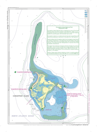
- Conception Island and its surrounding waters are a Bahamian National Park, established in 1971. It is a nesting place for seabirds, a sanctuary for migratory birds, and a feeding area for green and hawksbill turtles.
- The island is believed to have been visited by Christopher Columbus in 1492.
- The Bahamas National Trust has published guidelines for visitors to Conception Island. See guidelines and map below.
- Bahamas Area Websites. Sites that can be searched for tourist and business information throughout the Bahamas.
- Bahamas National Trust: Conception Island
- Bahamas Ecotourism
Anchorage
- West Bay at the NW quadrant of the island is the primary anchorage with protection from NNE to SSE. Access through the coral heads is easy following the above Explorer Charts.
- There is good holding in sand.
- Vessels should exercise care to avoid anchoring in or close to smaller coral reefs in the Bay.
- Booby Cay on the E side of the island offers protection from the W but has swells.
Ecology.
- Conception Island National Park is significant as one of the three islands where Columbus landed in the Bahamas. Today it is an unspoiled sanctuary for migratory birds and an important feeding habitat for juvenile green and hawksbill sea turtles.
- Conception Island is a no-take land and sea park and all flora and fauna are protected on land and in the sea out to 100 fathoms.
- Experts believe that Conception Island has the largest concentration of nesting White-tailed tropic birds in the Bahamas and that Booby Cays and South Rocks have one of the largest Sooty Tern and Brown Noddy colonies. The island has been designated an Important Bird Area by Birdlife International.
- The lagoon which occupies the center of the cay has extensive mangrove stands and beds of Laurencia red algae, many of which provide key nursery habitats for young Nassau grouper and spiny lobster. Since 1985 the Archie Carr Center for Sea Turtle Research has conducted an ongoing research program in the lagoon.
- The reef stretching N from the NW tip of the island is a Montastraea reef, the largest in the Caribbean. It is named for the species of corals that built it. These corals grow at depths from 0 to 80 m and several forms: heads, columns and plates.
- Visitors: Please report fishing violations or harm to nesting seabirds to the Bahamas National Trust at 242-393-1317 or email: bnt@bnt.bs
- Report whale sightings to BMMRO! Bahamas Marine Mammal Research Organization; 242-366-4155; 242-357-6666; info@bahamaswhales.org.
- See: Environment & Ecology for Cruisers
- Dogs must be leashed at all times to prevent disturbance of the nesting birds.
- Steve and Barbara on MV Foxy Lady work with the Archie Carr Center for Sea Turtle Research of the University of Florida at Gainesville. They have been conducting surveys and tagging operations since the mid 1980s. One of the mysteries they are working on are the "lost years" between when hatchlings head to sea and are then next seen as very young adults at feeding areas like Conception. If you see their vessel hail them for information on the area and the sea turtles. Check out: Facebook: Bahamas Sea Turtle Research; Website
Fishing
- Conception Island is a no-take zone in the area marked by depths less than 100 fathoms.
History
- People from Rum Cay established a settlement on Conception Island in the early 1900s.
- At the SE end of West Bay, a stone wall can be seen running inland from the rocky bluff. (23º 50.2' N, 75º 7.7' W)

- Ruins of 5 structures have been discovered on the point of land at the S end of West Bay and just N of the entrance to the saltwater creek. (23º 50.0' N, 75º 7.7' W)

- There is some evidence that the colonial government granted two leases for the island: in the 1800's to Chapman and in the 1900s to Dorset. Dorset is said to have established a small settlement for fishing and farming. These are the ruins seen S end of the West Bay anchorage.
- The vessel HMS Southhampton wrecked on the N tip of the reef stretching towards Cat I during the Revolutionary War while towing Vixen, a captured US brig. See: Wreck of the Southampton & Vixen
Moorings
- Three sets of red mooring buoys were donated to the Bahamas National Trust and have been placed in the NW corner of the anchorage for use by larger vessels. They are intended to protect the reefs from anchoring.
- The outer buoy has a 3000-lb. anchor and can hold vessels > 125'
- The two inner buoys can hold vessels to 125'.
- Note: March 2019, only two buoys in place.
Snorkeling & Scuba Diving
- Snorkeling the crystal clear waters of the mangrove habitat is a magical experience as many fish of all sizes can be seen among the mangrove roots.
- Turtles can be seen swimming in many areas of the lagoon. They take off at amazingly high speed when they see a dinghy,
- Good reef snorkeling along NW reef and at the S end of West Bay.
- Two white dive buoys have been placed on the Southampton reef to the N of the island and are maintained by professional dive operations. They have been placed to protect the reef from anchoring. They are available for use by all.
Things to See & Do
- The internal mangrove habitat is beautiful and magical to explore by dinghy. Access is over the bar of the creek in the middle of the SW shore. Entrance at 3/4 rising tide will give good depths and enough time to explore. Caution: Timing is important: a dinghy can be trapped by a falling tide at sandbars or at the sill at the entrance;
- The beach at West Bay is one of the most beautiful beaches in the world.
- There is good hiking around the NW and NE areas of the island.
- Cruisers once assembled some of the fishing floats that litter the E shore of the island to make a Beach Bocce game on the West Bay beach but these are gone — so bring your own bocce set.
- There are groves of stag-horn coral in a large protected cove at the south end of West Bay and along the N shore.
Trash
- The entire island is incorporated in the Conception Island National Park. There is no provision for trash disposals. Cruisers should take their trash with them.
Weather
- Visits to Conception require a period of settled weather as anchorages are subject to swells when there is any substantial N or S in the winds.
- The West Bay anchorage is not comfortable when the winds have any substantial N or S component.
- The anchorage should be avoided during a front passage with W-component winds.
Bahamas National Trust Guidelines for Visiting Conception Island
(provided by BNT)
- Conception Island is a no-take land and sea park. There is no taking of flora or fauna within the park which extends out to the 100 fathom curve.
- Anyone caught taking any plant, animal, seabird eggs, fish, conch, or crawfish will be liable for a fine, confiscation of vessel, and imprisonment.
- There are two moorings located northwest of Wedge Point. These moorings are owned by commercial dive boats but others are encouraged to use them.
- Boats visiting the park should anchor only in clear sand.
- There are no garbage facilities in the park. All garbage should be carried off the island at the end of your visit.
- Please observe 4 knots when traveling in the creek
- Dogs ashore on the main island must be on a leash, and please “scoop the poop.”
- Seabird Nesting areas are restricted from April 1st – August 31st. No visitation is allowed in these areas during this time period. No dogs are allowed in these areas at any time. These areas are clearly marked with signs.
- Please report violations to the Bahamas National Trust at 242-393-1317 or bnt@bnt.bs
Conception Island National Park
Official Chart [Full size, .pdf file.]
